A Scenic Tour Of Monument Valley (By Orbx)

A scenic tour of Monument Valley UT/AZ, this time with more narration based on a few viewer requests to hear more of what I’m doing and thinking in the sim. Happy to try that out. This flight is over the Orbx Monument Valley scenery (my first flight over it, in fact), in the A2A Cessna 172.

As for the landing, I’m too high over the threshold (still). But working on it.

I hope you like it, and thanks for watching.

Holy Cow! P3D V 3.3 Is Out!

The updates just keep coming. Here’s what Lockheed Martin has to say:

Prepar3D v3.3 is available now!

The Prepar3D v3.3 update brings several new features and numerous platform, rendering, SimDirector, SDK, and multiplayer updates – including improved rendering performance, enhanced stability and usability, an improved add-on installation process for developers, and numerous other bug fixes and improvements.

This new release welcomes the reintroduction of Multichannel. Professional Plus licenses now have the ability to utilize the new and improved Multichannel capability to configure multiple PCs to run Prepar3D concurrently, increasing performance on multi-screen and dome setups. This groundbreaking update further expands the immersion Prepar3D can provide and unleashes the ability to use multiple machines to create a high performing immersive training setup.

Additionally, add-on integration has been simplified for developers while also offering additional features for users, including the ability to enable and disable add-ons from within the application. Multiple monitor setups can be configured quickly using the new View Group Management window which also offers new advanced display settings including specific post processes per display that can be set up at any time. Support for Scalable Display Technologies Easy Blend™ is also included enabling multiple projected images to blend together on curved or flat surfaces. Several new usability features have also been added to SimDirector, including auto-save capability, more precise controls, and better visual cues when manipulating objects.

The Prepar3D v3.3 update is available now and can be downloaded from your Downloads page. If you currently own a valid Prepar3D v3 license, there is no charge to update to Prepar3D v3.3.

Prepar3D offers separate updates for the Client, Content, and Scenery. This will make updating faster and easier than ever before. Please be sure to read the Prepar3D v3 Download and Installation Directions for more details on how to quickly update to the v3.3 release. There is no update to the Scenery installer from v3.2.3.16769, so it is strongly recommended that those updating only download and install the Client and Content for this release.

The Lockheed Martin Prepar3D team loves hearing about your experiences with Prepar3D at our Forums. The forums also give us an opportunity to listen to your feedback as we continue Prepar3D development. We’ve partnered with our forum users and with several featured developers to continue to bring added features, enhancements, and optimizations all while bringing additional backwards compatibility, bug fixes, and stability to Prepar3D v3.3.

The full release notes are here. Can’t wait to try it out!

PilotEdge Alphabet Challenge Leg 6: Fullerton (KFUL) to Grand Canyon (KGCN)

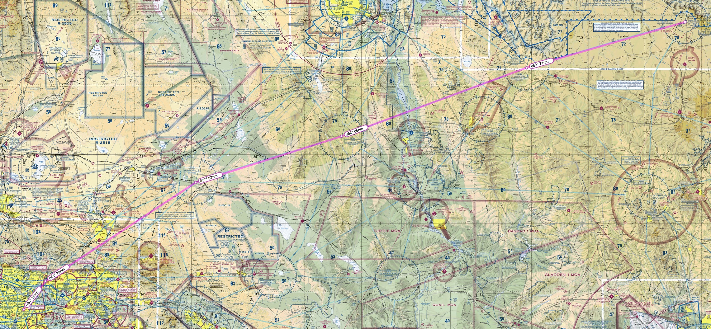
The final PE Alphabet Challenge post for now, leg 6, “F” to “G,” which is Fullerton to Grand Canyon. This is a long hop, over 300 nautical miles and about 2 hours 25 minutes start to finish. The plan was to fly via VOR navigation at 9,500 feet via the Pomona, Hector, Goffs, and Peach Springs VORs, with no GPS and no autopilot just to make it interesting. To save some time I used the A2A Cessna 182.
SkyVector__Flight_Planning___Aeronautical_Charts 3

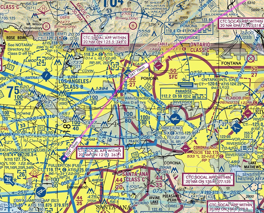
There are at least three major VFR considerations on this flight. The first is the complex airspace departing Fullerton. As you can see below, around the Fullerton airport you have the LAX Bravo (over the top), the Los Alamitos Delta (to the SW), the Brackett Delta (on the way), and the Ontario Charlie (also on the way). One way to fly this VFR would be to make a quick right hand turn on departure, stay below the 4,000 foot LAX Bravo floor, then quickly climb over 5,000 to clear the Brackett and Ontario airspaces. Or you could do what I did, which is just request flight following and talk to ATC the entire way, letting them handle the transitions for you.
SkyVector__Flight_Planning___Aeronautical_Charts 4

The second VFR consideration are the numerous restricted military training and operating areas along the way. The VOR route I mapped out flies between them. And finally, you have to figure out a place to land if the engine coughs. On this route there are lots of options early, but the rest of the way you’re thinking lake bed, highway, or desert scrub.

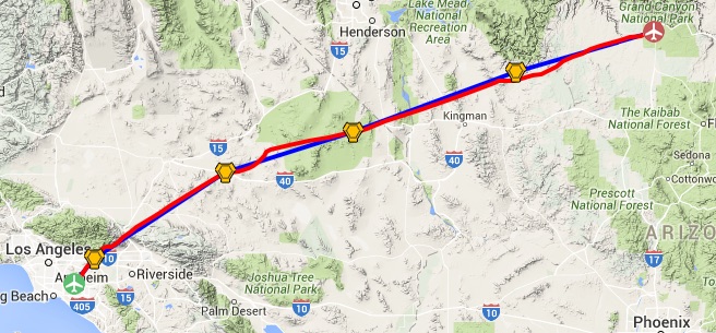
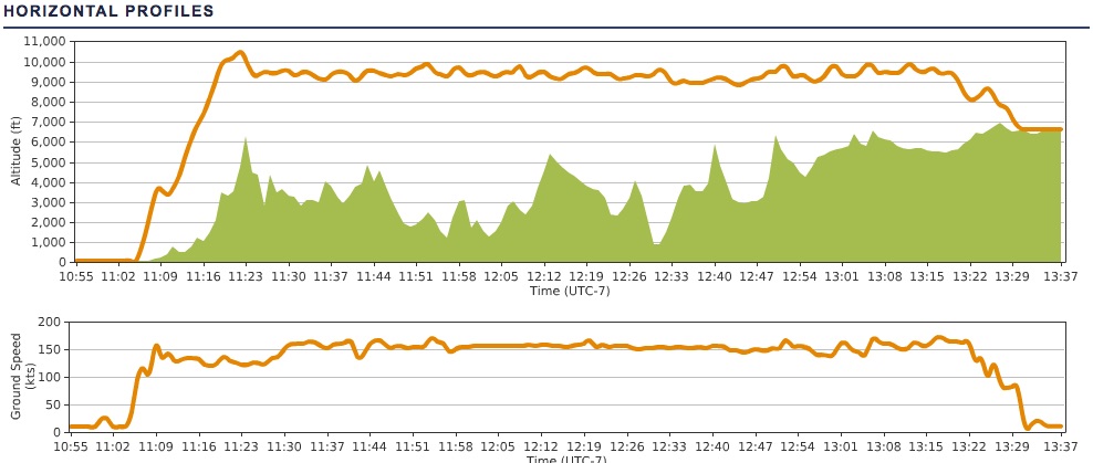
Here’s my actual route of flight and elevation profile. One of the very fair critiques of Prepar3d as a simulator is that it’s harder to trim the aircraft in the sim than in real life. I’ve only had four flights in my real-world instruction so far, but I find this is absolutely the case. It’s almost easier to just manage the yoke continuously than count on the elevator trim to hold an altitude. You can also see the little dip early in the flight where I descended to stay out of the LAX Bravo, which I did not have permission to enter. Finally, I was not yet picking up the Grand Canyon VOR after passing Peach Springs, so I veered a bit south just to stay clear of the Grand Canyon restricted flight area.
PEaware____N15JG_KFUL-KGCN

PEaware____N15JG_KFUL-KGCN 2

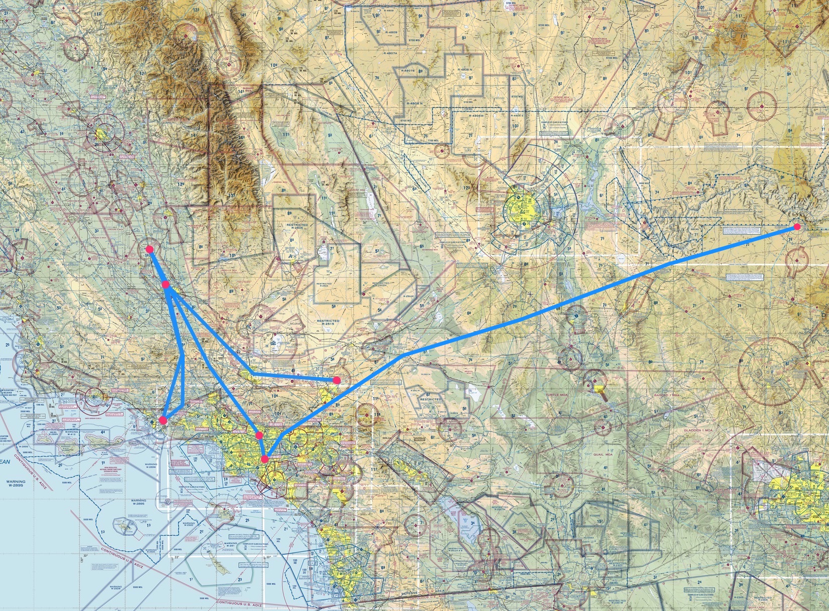
And here’s the current Alphabet Challenge progress map to date, with legs A-F flown (you can click it to see it much larger sized):
Alpha_Challenge_In_Progress_3

PE Alphabet Challenge Leg 4: Delano (KDLO) to El Monte (KEMT)

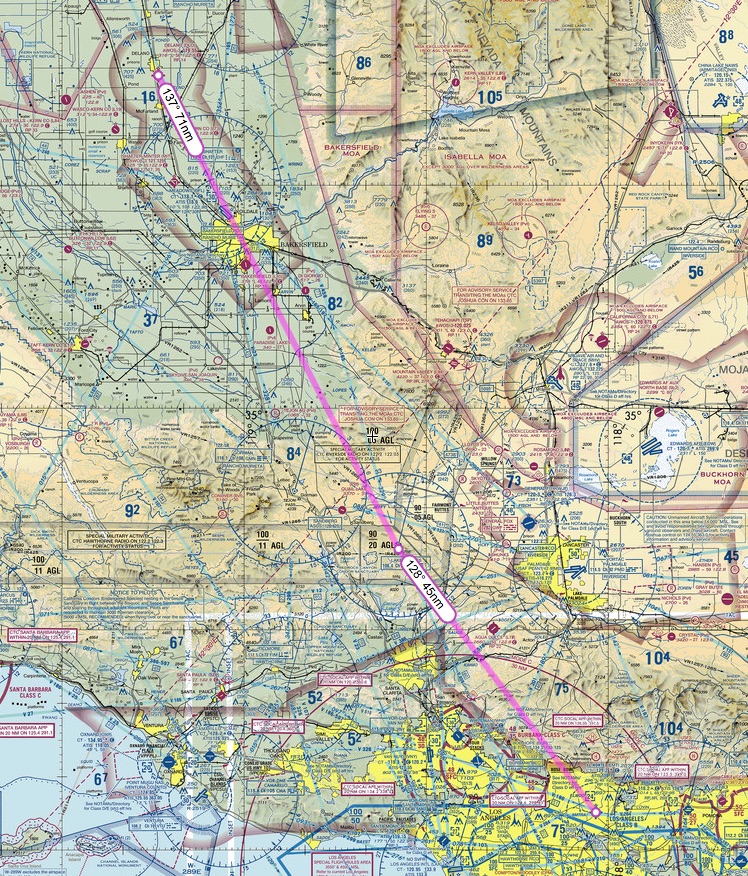
I’m backed up on a few PE Alphabet Challenge flight posts. Here’s the leg 4, “D” to “E,” which is Delano to El Monte. The plan was to fly VFR with VOR navigation via the Lake Hughes VOR, using the A2A Cessna 172 and autopilot:

SkyVector__Flight_Planning___Aeronautical_Charts 2

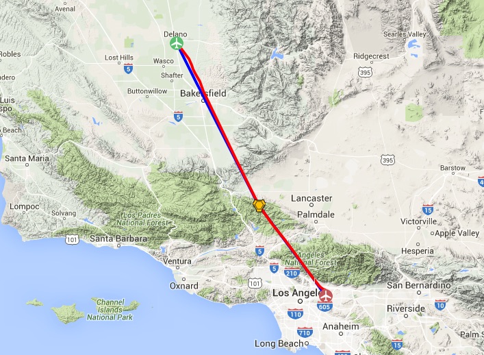
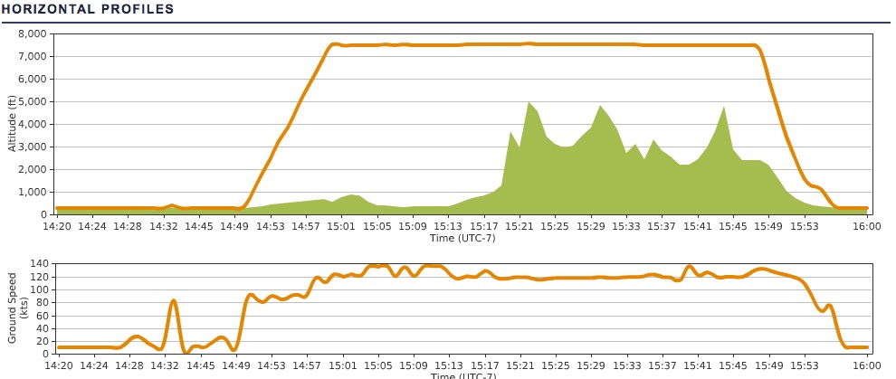
You can see what the autopilot does in terms of nice straight vectors and altitude profile:

PEaware____N15JG_KDLO-KEMT

PEaware____N15JG_KDLO-KEMT 2

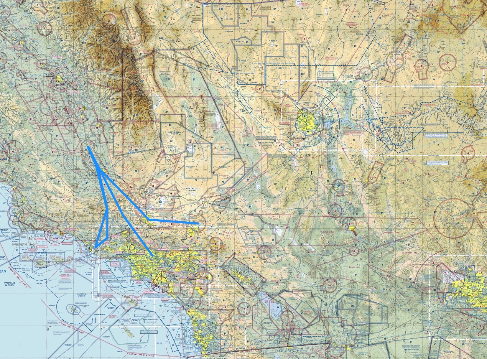
Have to go up high to clear the mountains and the condor sanctuaries. Here’s the current Alphabet Challenge progress map to date, with legs A-E flown (you can click it to see it much larger sized):

Alpha_Challenge_In_Progress 2